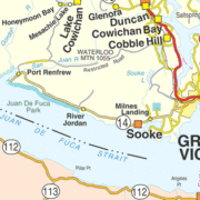
Manuel Quimper Benítez del Pino, Peruvian Explorer 1790
On May 31, 1790, Peruvian cartographer and naval officer Manuel Quimper Benítez del Pino explored and charted the Strait of Juan de Fuca. This Strait is the wide waterway stretching from the Pacific Ocean on the west to the San Juan Islands on the east, with Vancouver Island, Canada to the north. The international boundary between the United States and Canada runs down the center of the Strait. The Spanish extensively explored and mapped the western coast of the lands that much later became the US and southwestern Canada.
El 31 de mayo de 1790, el cartógrafo y oficial naval peruano Manuel Quimper Benítez del Pino exploró y cartografió el Estrecho de Juan de Fuca. Este estrecho es la vía fluvial ancha que se extiende desde el Océano Pacífico al oeste hasta las islas San Juan al este, con la isla de Vancouver, Canadá, al norte. La frontera internacional entre Estados Unidos y Canadá se extiende por el centro del Estrecho. Los españoles exploraron y cartografiaron extensamente la costa occidental de los EE. UU. Y el suroeste de Canadá.